


Last month Sophie South, our Principal Civil Engineer enjoyed a family walk through a subdivision Davis Ogilvie has been a key part of over many years. Sophie was out checking on the performance of a stormwater basin that we designed. It was full of water, working as designed, prompting questions from her kids.
Given that not all of our clients are necessarily stormwater experts, and that Councils are currently heavily investing in them, we thought it might be useful to explain a little more about how they work and why they are needed.
Stormwater basins are specially designed areas that collect and temporarily store rainwater runoff during heavy rain events. They help manage flooding, improve water quality and support local ecosystems. You may have heard other names for them used such as swales or retention basins. All these are variations of the same concept and have similar roles.
You may have noticed large sunken green areas, often planted as wetlands, across new residential developments. Council has also built their own larger scale basins. Some of the largest ones can been seen from the Southern Motorway in Ōtautahi Christchurch, close to Ngā Puna Wai.
Capture: When it rains, water flows off roofs, roads, and other hard surfaces into stormwater drains.
Storage: The water is directed into stormwater basins, where it is temporarily stored.
Slow release: After the peak of the storm, the water is slowly released into nearby rivers or streams to prevent flooding.
Filtration: Many basins include wetlands or vegetated areas that help filter out pollutants like sediment, oil, and litter before the water reaches natural waterways.
The Heathcote River/Ōpāwaho catchment in southern Christchurch is where the city has heavily invested in this critical infrastructure to protect people and property.
Prior to European settlement this area was a spring fed wetland, part of a network of waterways that surrounded the Port Hills, giving the impression that the peninsula was an island. Since settlement the area was effectively drained through various measures including placement of stop banks redirecting the Waimakariri River, to allow for farming and more recently residential housing development.
The area was significantly affected by 2010/11 earthquakes with land sinking, in some areas, to below the normal height of the river.
Additionally, the Heathcote River/Ōpāwaho is very tidal, with river water being unable to flow out to sea against the incoming tide.
In a large rain event, and especially during an incoming tide, this means large volumes of water needs to go somewhere to not threaten/flood homes and critical infrastructure.
In response, the Christchurch City Council has developed a network of stormwater basins in the Upper Heathcote area to manage this risk.
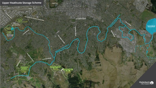
Upper Heathcote Storage Scheme – credit to Christchurch City Council.
Key features of this scheme:
Flood protection: Basins like the Curletts Stormwater Basin and Wigram East Basin can hold millions of litres of water, reducing flood risk during major storms.
Water quality: These basins include treatment wetlands that clean the water by removing sediment and contaminants.
Public spaces: Many basins are designed as multi-use areas, offering walking paths, native plantings, and habitats for wildlife.
Wigram East Basin stores up to 520 million litres of water (about 236 Olympic-sized pools) and includes 4 hectares of wetland.
Stormwater basins are a nature-based solution to urban water challenges.
In the Heathcote catchment, they:
—
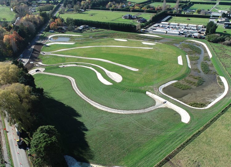
Davis Ogilvie (DO) is a multidisciplinary consultancy that provides comprehensive engineering, surveying and planning services, as well as specialist expertise in civil, geotechnical and structural engineering, resource management and environmental sciences. We have designed and overseen construction of basins that have been vested in council ownership and provide the benefits discussed above, such as the recently completed basin servicing the Oakbridge development in the photo below.
With a legacy of over 90 years, we have a wealth of local knowledge and experience, with South Island offices in Christchurch, Nelson, Greymouth and Timaru. Whether it is a multidisciplinary or a standalone project, we can help.
From dirt to development, resilience to recovery, DO provides collaborative efficient solutions. DO delivers.


